As extreme weather intensifies, destructive wildfires pose an increasing threat to people, property and native flora and fauna.
While cool-season burning is increasingly recognised as an important investment in building landscape resilience against high-intensity fires, demonstrating its effectiveness at scale has remained a challenge.
NRM Regions Queensland, in collaboration with regional NRM organisations and fire specialists, is addressing this gap through the development of a new Fire Condition Assessment Tool (FireCAT). The tool is designed to demonstrate the effectiveness of improved fire management practices and is supported by funding from the Queensland Government’s Natural Resources Recovery Program.
NRM Expansion Program supports FireCAT pilot
Cape York Peninsula is Queensland’s most fire-prone landscape, with vast areas burned each year. Cape York land managers have identified improved fire regimes as a top regional priority.
In the absence of proactive fire management, large and intense late dry season wildfires can devastate the region’s remnant vegetation. This progressively degrades vegetation structure, reducing biodiversity values and increasing soil erosion risk ahead of monsoonal rains.
Cape York NRM’s Wildfire Resilience project, funded by the Queensland Government’s NRM Expansion Program, will deliver coordinated cool-season burning across 40,000 hectares to enhance vegetation resilience and reduce wildfire risk. Building on previous work to expand coordinated fire management across the region, the initiative has been selected as the official FireCAT pilot.
By using FireCAT to monitor this area, the project aims to move beyond anecdotal evidence and provide data-driven insights into how improved burning regimes reduce the threat of wildfires and protect vegetation.
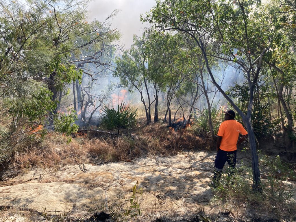
Early dry season burn in Cape Melville National Park (CYPAL) Credit: Cape York NRM
How FireCAT works
Traditionally, measuring the success of fire management efforts has relied on case studies and narratives. There has been no consistent method to generate an objective score about how fire patterns change over time across large, remote areas — until now.
FireCAT has been designed to overcome this challenge. Unlike other monitoring approaches, it does not require actual fire data to be collected in the field. Instead, it uses fire scar mapping from the Northern Australian Fire Information (NAFI) system to assess patterns over time.
The tool evaluates fire patterns within a defined project area over the past 10 years and determines the “health” of those patterns each year based on criteria including:
- the percentage of the project area burnt that year;
- the proportion of fires occurring under suitable weather conditions (cool and moist enough to prevent destructive, runaway fires);
- the size and distribution of fire scars, with many smaller fires preferred over a few large ones;
- the amount of fire-sensitive vegetation that was impacted by fire.
From this data, FireCAT generates an annual fire pattern health score, along with an average score across the full 10-year period. As active fire management is implemented over time, changes in these scores can provide evidence of strengthened landscape resilience to wildfire.
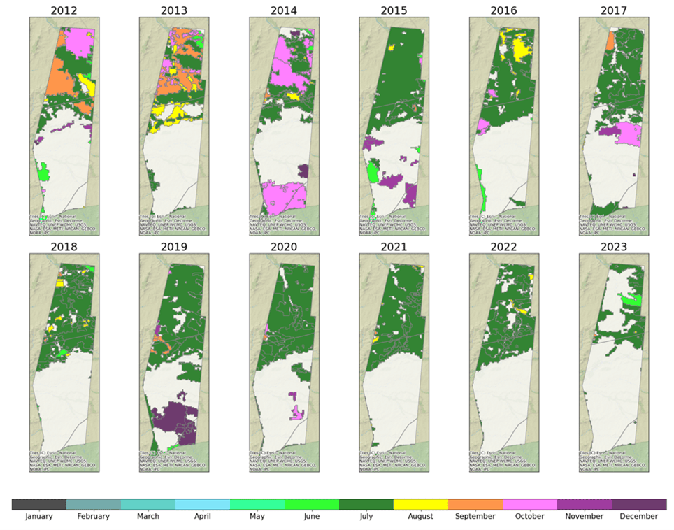
Example of the fire scar mapping generated by FireCAT from NAFI data.
Supporting planning and investment
FireCAT produces more than a single score; it is a practical resource for future planning and community engagement. The reports it generates include maps, graphs and explanatory insights that help regional NRM organisations plan for future fire management and communicate the impact of their work.
By providing clear, evidence-based results, FireCAT helps quantify the difference improved fire management makes to landscape-scale fire patterns. Over time, this approach is expected to reduce the likelihood of large-scale wildfires. In doing so, FireCAT strengthens the case for continued investment in cool-season burning and supports efforts to build more resilient landscapes across Queensland.
FireCAT is the latest Condition Assessment Tool developed as part of the State-wide Indicators Framework, which provides organisations delivering NRM projects in Queensland with consistent methods for collecting project impact data. Data collected through FireCAT will be analysed using custom computer scripts and combined into a state-wide dataset that feeds the online SWIF dashboard.
This project is funded by the Queensland Government’s Natural Resources Recovery Program.
